The West Coast had had a lot of rain, everything was sodden, but this is what grows all the wonderful and amazing green bush. The rain had caused ten slips at Jackson Bay, one of them huge which closed the road and isolated the people at Jackson Bay - 1st named Open Bay by Captain Cook, the origins of the Name Jackson Bay is unknown.
I thought I would go as far as I could, which was to Neils Beach.
This is at Waiatoto, a tiny place as the road leaves the coast, crosses the Waiatoto River then travels inland to the Arawhata River then out to the coast again at Neils Beach.
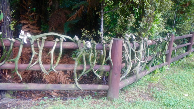
I stopped here just to have a look and saw all these deer antlers on the fence. Somebody likes hunting!
Something grows on every available surface - look at the tree fern trunk !
I got to Neils Beach, a few houses there and a back-packers but it was raining hard so I didn't stop.
Turned around at the road block and went back.
Tribute to a West Coaster - Dan Greaney 1900-1972 - Jackson Bay Roadman - Widely respected for his love of native and care for the environment...
Surprising what you find in the most unexpected places!
This was my last stopping place on the west coast, next through the Haast Pass. I was reluctant to leave. My whole time on the coast had been magical, so much history and information about the early years and pioneers.
In December 1990, Mount Aspiring National Park accepted a new status - World Heritage. It became a part of the newly created Te Wahi Pounamu (South-West New Zealand) World Heritage Area, taking in a vast region of 2.6 million hectares from Mount Cook to southern Fiordland - a tenth of the land area of New Zealand. Four years earlier Fiordland, Westland and Mount Cook National Parks had been declared UNESCO World Heritage Areas.
This internationally recognised area, 450km long, ranges from Okarito on the West Coast to the Waitutu forests of the great southern lakes, including the country's last big stands of kahikatea forest. Te Wahi Pounamu is the remotest, wildest region of mainland New Zealand, a place crammed with natural features of world significance.


No comments:
Post a Comment