Friday 26 February 2016

The End of the Road... To Jackson Bay

I spend two nights at the Haast Beach camping ground. I felt so grubby, dusty and lots of sandfly bites. I had four showers in thirty six hours, washed my hair twice... And did all my laundry and line dried it... Then time to be on my way again.
The West Coast had had a lot of rain, everything was sodden, but this is what grows all the wonderful and amazing green bush. The rain had caused ten slips at Jackson Bay, one of them huge which closed the road and isolated the people at Jackson Bay - 1st named Open Bay by Captain Cook, the origins of the Name Jackson Bay is unknown.
I thought I would go as far as I could, which was to Neils Beach.

This is at Waiatoto, a tiny place as the road leaves the coast, crosses the Waiatoto River then travels inland to the Arawhata River then out to the coast again at Neils Beach.
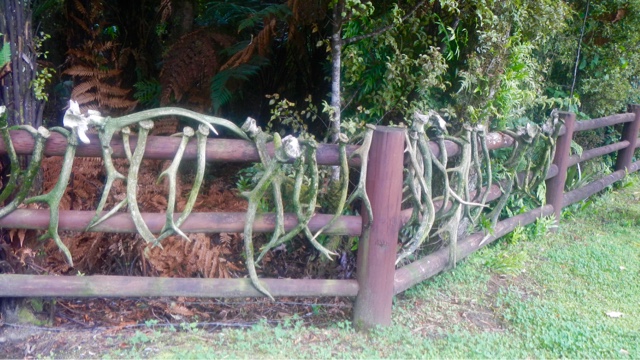
I stopped here just to have a look and saw all these deer antlers on the fence.  Somebody likes hunting!

Also this stunning green wet bush. Imagine having this for your back yard.
Something grows on every available surface - look at the tree fern trunk !

The road continued...

Through this lush dense bush which both grows prolifically and rots from all the rain. 
I got to Neils Beach, a few houses there and a back-packers but it was raining hard so I didn't stop.
Turned around at the road block and went back.

Coffee time... So I parked here at the Arawhata River.

This path down towards the river goes to a memorial...

Tribute to a West Coaster - Dan Greaney 1900-1972 - Jackson Bay Roadman - Widely respected for his love of native and care for the environment... 
Surprising what you find in the most unexpected places!


The Arawhata bridge and river.

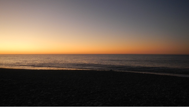
This was my last stopping place on the west coast, next through the Haast Pass. I was reluctant to leave. My whole time on the coast had been magical, so much history and information about the early years and pioneers.

In December 1990, Mount Aspiring National Park accepted a new status - World Heritage. It became a part of the newly created Te Wahi Pounamu (South-West New Zealand) World Heritage Area, taking in a vast region of 2.6 million hectares from Mount Cook to southern Fiordland - a tenth of the land area of New Zealand. Four years earlier Fiordland, Westland and Mount Cook National Parks had been declared UNESCO World Heritage Areas.
This internationally recognised area, 450km long, ranges from Okarito on the West Coast to the Waitutu forests of the great southern lakes, including the country's last big stands of kahikatea forest. Te Wahi Pounamu is the remotest, wildest region of mainland New Zealand, a place crammed with natural features of world significance. 


Wednesday 24 February 2016

Bruce Bay... An Icon of the West Coast...

Bruce Bay... But the beach is Maori Beach. I stopped here for morning coffee. A beautiful day.
I could have stayed a week or more... But I didn't.

On the other side of the road the wild flaxes and bushes. You can see the effect of the prevailing 
wind from the west.

At the north end there is an overnight parking area... I have already decided I will be exploring the West Coast again. Too much to see and not enough time...

Out there somewhere... Is Australia...

Oh well... Moving on...

Over the Mahitahi River...

To... Well I don't know yet!

Gillespies Beach

From Franz Joseph I walked round Lake Matheson, not a very good day with a bit of wind so the reflections were poor and I'm sure you have seen zillions of photos of that lake. On the drive there very good views of Fox Glacier.
Next stop was Gillespies Beach. It's about 16km west from Lake Matheson. The road description is not good so I enquired at Doc then off I went. It's hard dirt, narrow, windy, absolutely beautiful bush right to the side of the road and passing wasn't impossible. There is a Doc camp right by the beach, big vehicles in the car park and plenty of grass areas for tents. I got there by late lunch time, a few others there but by early evening it was packed and standing room only.
It's another amazing place...


A stunning beach. A few brave souls were swimming. I tried fishing but the waves just tossed my line back in.

This is the back side of Mt Cook on the right and Mt Tasman on the left. The GPS told me they are 21km away.
It was a surreal feeling standing on the hot stony beach, blue sea on one side, snow covered mountains on the other.

Along with lots of others I sat on the beach and watched the sun set into the sea...


The last rays of sun on the mountains.

Sunday 21 February 2016

Lake Ianthe... And a Salmon!

This is Lake Ianthe, quite a small lake not far south of Hokitika.

The parking, although a DoC camp is a tiny area just off the road. Only parking for about four vehicles.
I was feeling a bit stressed when I got there late in the day. The day had been busy and a bit rushed...

So what better relaxing therapy than fishing. There was a small jetty so that's where I spent the evening as it got dark looking at this beautiful view and darkening sky.
I was feeling better and it was nearly dark... And snap... Definitely a fish. It didn't fight much and as it's the first fresh water fish I have caught - finally! I had no idea what to expect.
It was easy to put my net underneath it and lift it out...

I had no idea what it was... It had to be a trout or a salmon of course... I cut off it's head and tail and gutted it. The skin produced an amazing amount of slime... It got washed and onto a plate in the fridge to be investigated more in the morning...

It turned out to be a sea run salmon... Just look at the colour of it.

I smoked it and here it is ready to eat... So fresh and yummy. 
I want to go back there and catch another one of course! I've been fishing in lots of rivers and lakes...
But so far this is my only fish.

Wednesday 17 February 2016

Hokitika Gorge...

This place is an absolute must go there place. The day we went it was pouring with rain.  There is only a small car park so big vehicles were difficult and the torrential rain made it worse... But it's spectacular...

All my wet weather gear on...

Not very far round the track till the first glimpse of this stunning water and gorge.


The water is an intense blue... Ingredients are rock flour, melted glacier ice, river water.  The rock flour is made by grinding down schist and greywacke rock into fine particles. Combine rock flour with a dash of melted ice and minerals from ancient glaciers. Continuously add to river water. The result is a gorgeous milky, turquoise coloured river.


A lot of rain was falling the day we were there but it creates this beautiful bush and very unique 'West Coast'.

The track took us to this lookout then down onto this small beach...


The white spots are rain drops... It was so hard to keep my camera dry... Impossible really.

The Hokitika River is 64km long starting in the Southern Alps. It emerges from this gorge merges with the Whitcombe River and flows into the Tasman Sea just south of Hokitika.

This walk is the top rated walk in Hokitika on Trip Advisor...

Lake Kanerie

Although I am no longer exploring the West Coast I have to show you a few more of my favourite places. 
I had been looking forward to the West Coast beaches and sunsets but I was surprised by all the beautiful lakes.
This is Lake Kanerie in the Hoklitika area...

The early morning mists...

And reflections... Perfectly still before the day really starts and the wind comes up...

This lake is 30km southeast of Hokitika, drains into the Tasman Sea via the Kaniere and Hokitika Rivers. It has a surface area of 22km and is 2nd only to Lake Brunner in size. It is popular for boating, fishing, picnicking and water skiing although at this perfect time of the morning, nothing was happening... So peaceful...

There is a very nice DoC camping area, elevated in terraces above the lake. It's very popular. 
This track goes to the toilet block and lake edge...

Native Toetoe with their feathery plumed flowers... I was brave and had my first West Coast swim here!