Saturday 30 January 2016

Beautiful Franz Josef Glacier...

Today was a lovely fine day. It has finally stopped raining after about two weeks of rain with a few fine hours here and there. It was wonderful to be out and about not bundled up in my leggings and raincoat. I took the opportunity to walk to the Franz Joseph Glacier while the day was clear to see the top of it and the floods from all the rain have receded and the track is open...

This notice is at the beginning of the track and the photo below is right beside it. The walk is about 4km return which means the glacier has retreated 2km since 1867...


The first part is a very well formed track... And not far before the first glimpse of the glacier...


The stony riverbed of the Waiho River which is fed from the melting glacier and all the waterfalls and the rain of course!  This notice made me laugh... Who would want to go swimming here?

Amazing waterfalls gushing down the Rocky Mountain sides...


Enormous piles of rocks and stones left behind by the retreating glacier...


There is so little of the glacier left to see from the view point at the end of the track. Where I am standing is 300m high. The glacier goes another 9km and rises to 2800m. You could only see 
this from a helicopter. 
The blue ice in the middle in the front is an ice cave...

Here it is close up... With binoculars I could see the foam and spray inside the cave from the river that is rushing down the crevasse.. It's all very stunning and geographically amazing...


Thursday 28 January 2016

Rain... Rain and More Rain...

After tiki touring round some of the side roads and finding amazing little beaches my destination was the Fox River - Woodpecker Bay at Tirimoana. TD # 6507. It was fine and sunny but by early evening it started to rain and not just rain but heavy rain. It rained all night. I got up early to check the river level as I, along with several others, small vans, caravans and motor homes, were parked in  a car park right beside the river... And I know how these river can flood so quickly. 6.30am all was fine so I went back to bed. By 7.30 there was banging on my door and horrors when I looked out there was brown water everywhere, lapping onto the bottom step inside my bus. The flooded torrent of river had met the high tide...
I moved over the road onto higher. ground, parked with three other old Bedford house buses put on all my wet weather gear and ventured out to have a look...

This is where I was parked... Everyone moved except one vehicle, the owner must have been walking the track into the mountains.


It was wild and windy and raining and all very spectacular... The photos tell the story...

The next day as the river went down I walked round the bridge. The river had dropped at least six - ten meters. The force of the water had gouged out massive amounts of stones...


Major amounts of driftwood and trees... And some blue sky...

The river's going down, shingle banks are beginning to appear again... But it's time for me to move on... To my next adventure!

PS... The phone and Internet reception is very patchy all along the west coast so hence big gaps in telling you my stories...

Monday 11 January 2016

Tiny Hidden Beaches...

After leaving Westport heading south I took a side road called Beach Road. I had no idea where it went but it seemed a good road to explore... And it was... It was narrow and wound around with no stopping places until I came to another side road down a hill that took me somewhere I could park, a little street with houses, a picnic area at the bottom, a beach and a walk. So off I went, walking is the only way to see places that are tucked away...


This is Giant Mermaids Hair swirling round in the waves... I didn't see the mermaids though!


It was a loop walk, not very long and no signage but my map tells me I'm parked at Joyce Bay and walked to Constance Bay and Doctor Bay. It's all very beautiful and such open, vast and unpopulated scenery. I'm loving the West Coast.

Carters Beach Westport...

This is Westport's main beach so I stopped to have a look and sat in the sun with my morning coffee.
It's a beautiful beach, good fishing no doubt but when the westerly wind, which is the prevailing wind is blowing I think it would be very cold and unpleasant...


Sunday 10 January 2016

My Next Three Nights... At The Star Tavern Pop...

After walking the Cape Foulwind walk from the south end I drove to the north end to have a look and found this wonderful place to park. It's a mown paddock nex to the Star Tavern and it's totally free. unless you use power.


I was intrigued by these palms beside my bus... All growing out of a fallen trunk...

This is where I parked and my view out to the amazing and frequently changing Tasman Sea.
This is a reserve area, the paddock where I am parked belongs to the owners of the pub.
At the far end of this grass is a steep track that goes down to the beach below...


Amazing rocks sculpted by the harsh winds over the centuries...


And... Around the beach a bit further are these flat rocks covered with millions of tiny blue mussels...

But if you look a bit further, where the waves still wash over the rocks at low tide, there are big fat mussels for the taking...

And of course I did... Along with a couple of others also parked there... We fossicked together...
What a feast...

Mussels fritters for dinner of course... After we had patronised the pub and sat in the garden in the sun and enjoyed a beer or two... Lovely locally made Westport organic lager...
I stayed here three nights and could have stayed much longer... But more adventures were waiting for me...


Cape Foulwind...

I did this walk on the most beautiful day... Stunning scenery... The walk goes from Tauranga Bay to the lighthouse and car park at the north end


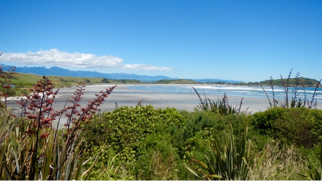
I started from Tauranga Bay, the south end...


The name Tauranga refers to the sheltered anchorage the Bay provided for Maori canoes. It was renowned for the quality of the shellfish gathered here, particularly mussels and also the abundance of seals, fish and birds...

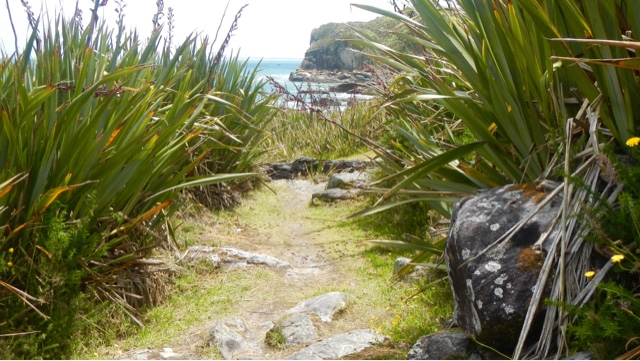
The flax is prolific and the flowers a stunning red...

This is Wall Island. A seal colony is on the rocks below here...

This is an Astrolabe... Able Tasman used an astrolabe like this to establish his position off this coast in 1642
The astrolabe is an instrument for determining the latitude by measuring the altitude of the sun at noon. A chart called an Ephemeris is used with the astrolabe to show the location and altitude of the sun for the calendar year.
Each day at noon a sighting is taken of the sun. The angle of the sun at noon is taken off the astrolabe.
The position of the sun at noon each day is known by looking at the Ephemeris for that year.


Siberia Bay... So called by the mining men who worked here quarrying the rocks. They dug tunnels, placed dynamite at each end then blasted the rock. Cranes loaded it into railway wagons and took it 12 km's to be used for building breakwaters. In 1914 the railway was extended to Tauranga Bay, a tunnel was built under the present walkway, since collapsed. The Buller River breakwater was built from stone quarried here in the 1960's. It was called Siberia Bay because of the freezing south westerly winds that blew in. 


The lighthouse in the distance...

The old lighthouse...


The new lighthouse... 

This is as far as I walked, overlooking the carpark at the north end of the walk, Gibsons Beach and back into Westport town. Then I had to walk back again! Somehow it's always a faster return walk.